Building An Empire
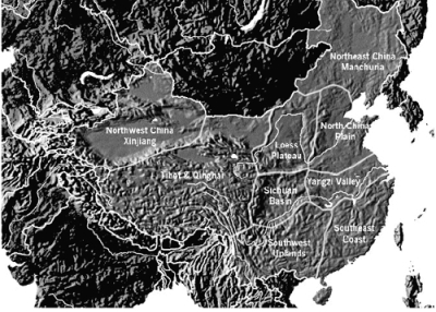
Mapping China
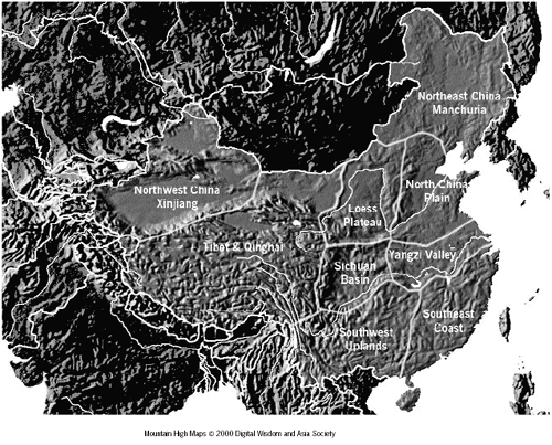
Students understand China and its geography by creating travel brochures for China's nine distinct regions. Groups then combine their brochures into a bulletin board map of China, discussing commonalities and distinctive features. A simplified version of this may be used in Chinese language classes, wherein students describe the regions in Chinese.
- Mapping information about people, places, and environments
- Understanding the characteristics, functions, and applications of maps
- Investigating why people and places are located where they are and what patterns can be perceived in these locations
- Describing the relationships between people and environments as well as the connections between people and places
- Formulating questions and defining geographic issues and problems
- Using a number of research tools (electronic databases, periodicals, census reports, maps, standard reference works, interviews, surveys) to locate and gather geographic information about issues and problems
- Presenting geographic information in a variety of formats
- Interpreting geographic information by synthesizing data and developing conclusions and generalizations about geographic issues and problems
- Independently selecting and applying strategies for collecting and synthesizing information, such as note cards and bibliographies
- Using a variety of reference books and other data sources to gather information and generate independent understanding about a topic
- Taking research notes and composing a report
Student-created regional map of China, travel brochures, oral presentations.
- What have been key issues for the Chinese, given the vastness and diversity of land?
- How have variations in landforms and climate affected Chinese throughout history? And today?
- Using a projector, make an enlarged version of the map on butcher paper (about the size of a bulletin board). Cut the map into the nine regions of China.
- Photocopy and distribute the blank Terrain Map of China handout.
- Divide the class into nine small groups and ask students to divide China into regions based on the natural features.
- Distribute the Regional Map of China, and the Destination China! handouts marking the nine geographic regions of China.
- Assign one region to each group. Have students use travel guides, augmented with atlases, reference books, or resources on the Web to research their assigned region’s major features and create a travel brochure according to the handout.
- Have groups reassemble the map of China and present research information, attaching their brochures to their region.
Have students look at a terrain map to divide their home into subregions. Ask them to create collages that address the terrain, climate, industry and economy, housing/shelter, and diet of their home region. Lead the class in a discussion of the similarities and differences among the individual collages.
Consider staging a national conference, whereby each group serves as representatives of their region. They present, as an open letter to the nation, a list of three to five of its significant contributions and outline two resources/commodities/services for which their region is dependent on others.
Copyright 2000. Author: Joan Arno, Joan Barnatt, Nancy-Jo Hereford.